
Now featured
in the Lycos
Chattanooga
City Guide
Check the Release Schedule at OAR , my recommended outfitter for Ocoee runs
I now live on the west coast. Better pictures and updates on the rapids are gonna have to come from you! NEW: 4 years after moving to California, I got back and shot some pictures.
Note: This guide is intended as a basic overview of the Ocoee, both to see if it's a river you want to paddle and to provide a view of what the river is like, give you some background, and help make your experience more enjoyable. It is not a substitute for experience, skills and proper training. If you're new to whitewater, I suggest rafting with a commercial guide. If you're an experienced paddler, you should feel comfortable on class III water before attempting this river at normal water levels (1250 CFS), and do so only as part of a group.
I want my readers to understand that the suggestions here are guidelines only, and will change depending on any number of factors. I have rescued too many people, in this and other high-adventure sports, to believe that all of the readers of this page will take this in the spirit that it's presented, but I sincerely hope that few enough of the rest of you die to become a problem for me and other more intelligent readers.
|
Other Ocoee sites: |
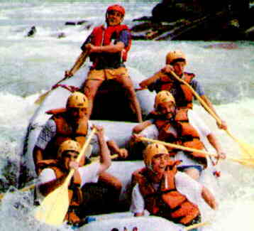
On Saturdays in July and August the river gets incredibly crowded, as the commercial outfitters push down over 4,000 people a day (over 125,000 a year), but on weekdays (A different set every year, usually Monday, Thursday and Friday, and only during the mid-season) and early and late in the season, it has just enough other people around to make your trip a social occasion as well as a basically fun run.
Rare in the southeast, the Ocoee has only 3 potentially dangerous undercuts, all of which are easily avoided, and although there are the usual opportunities for injury, the forgiving nature of the Ocoee makes it a good place for less experienced paddlers to play on water that would normally be solid class IV.
I was a commercial guide on the Ocoee since 1989 with High Country and, later, Outdoor Adventures Rafting , along with mercenary work for various other companies, until I moved to the west coast in 1995. Most of the naming of rapids (and parts of rapids) comes from that experience; where I know of multiple names for a feature I'll point all that I know of out.
I have run the section above the usual commercial stretch at flood stage several times, where the Olympics were held, and was one of the few guides to ever have run a commercial trip on that section before the remodeling. I haven't been back to see the changes, so I can't speak authoritatively.
Just because the Ocoee is normally dam controlled by the TVA doesn't mean that it always runs at the 1,250 CFS (cubic feet per second) that the commercial outfitters are guaranteed during the season. Commercial outfitters can, by state law, run the Ocoee up to 3,000 CFS, and I know of an unsuccessful attempt to run the top half at over 22,000 CFS (One of the two boaters swam at Slice-n-Dice and was gotten to shore by the other at Double Suck(!)). I've personally run the bottom half (Goforth Creek to the takeout) at somewhere between 13,000 and 18,000 in a kayak, seen Dixie Drive to the end run in a raft at well over that in the middle of the night (now that's a story), and run the rest of it in several different types of boats at many levels in between. Further, very enjoyable midnight and off-season runs have been done as low as the 700-900 CFS range.
The authorities which control the area (State, county and local police and the park service) will no longer use force to keep you off the river, but unless you're really experienced in running flood stage rivers and have a basic death wish I'd be extremely wary of any level above 6,000 CFS, especially on the top half, use many of the cheat routes at anything above 2,500 CFS, and listen to the suggestions of Lance, Jaime(sp?) and the other rangers. Yes, they aren't paddlers and don't know how hot you are, but it's easy to die on flood-stage rivers. There are lots of dead heroes. Don't be one.
Class ratings are based on the I-VII (Nealy modified) scale, but are my own interpretations, trying to remain consistent with what else I've run (especially recently, since I've been paddling lower level stuff). Many experienced guides will call this only a class III river due to its lack of screw-up factor, I've tried to make it more consistent with an "upright and dry" rating than a "survivability" rating.
| DO NOT park in the spaces alloted to the commercial outfitters, in the limited time spaces for longer than it takes to load (and do it fast!) or drive through any congested area you don't have to. Don't site-see from a parking space that paddlers may use or in a busy loading zone. The nicest thing that will happen to you is you'll get a paddle through your windshield or a bus will run over your car. And I'll cheer them on. |
From Chattanooga Tennessee, going north on I-75, take the first Cleveland exit (Highway 64 Bypass). Go to the Highway 64/Ocoee exit. Follow 64 to the Ocoee, which will be on your right. There's a new takeout (which I haven't seen) below the main commercial takeout. I don't know what the new parking situation is on the bottom, but there's a gravel lot at the put-in.
Hitchiking is easy, even in the evenings locals will usually pick you up. Those standing at the downstream side of the commercial takeout are generally assumed to be guides waiting for outfitters buses, you're wasting your time if you stop to pick these folks up or if you wait there. Wait and pick up at the upstream end.
It is not a good idea to leave your boat and/or gear unattended for a shuttle. Too many boats get stolen; the days are gone when you could go up alone and leave your boat lying on the grass when you shuttled, although in the busy parts of the year you can often find someone willing to shuttle your boat as well as you. At least bring a lock and chain.
The stretch of river normally referred to by whitewater buffs as "The Ocoee" is the 4.8 miles between the TVA #2 dam and the TVA #2 powerhouse . Highway 64 runs along one side of the river, the flume line, which carries water from the dam to the powerhouse, along the other.
Goforth Creek runs into the Ocoee at the end of The Doldrums , about mid-way down the river, and makes a nice put-in for first time Ocoee paddlers who don't mind the bigger water of the lower half but would find the technical aspects of the upper half too challenging.
I suggest you start at the top and work down, but for those of you who like to jump around, here's the list of rapids, in order:
This is a part of the Virtual Ocoee pages of Dan's Whitewater collection in the home pages of Dan Lyke , reachable at danlyke@flutterby.com