modern archeology
2007-09-14 14:47:18.234028+02 by
Dan Lyke
17 comments
[ related topics:
Photography Boats Machinery Maps and Mapping
]
comments in ascending chronological order (reverse):
#Comment Re: made: 2007-09-14 16:25:44.985248+02 by:
JT
My girlfriend and I love to kayak around Lake Isabella, CA. Although much more recent, the town of Kernville existed where the north end of Lake Isabella exists today, when the Isabella Dam was created in 1948, the old town was flooded over. Due to the drought this year, the lake has been drained to below 25% capacity supplying water to Bakersfield's farmers and residents which has exposed some amazing 1840's to 1860's house foundations, river locks, and such some seemingly (to me) unidentifiable cement structures as the lake gets lower and lower.
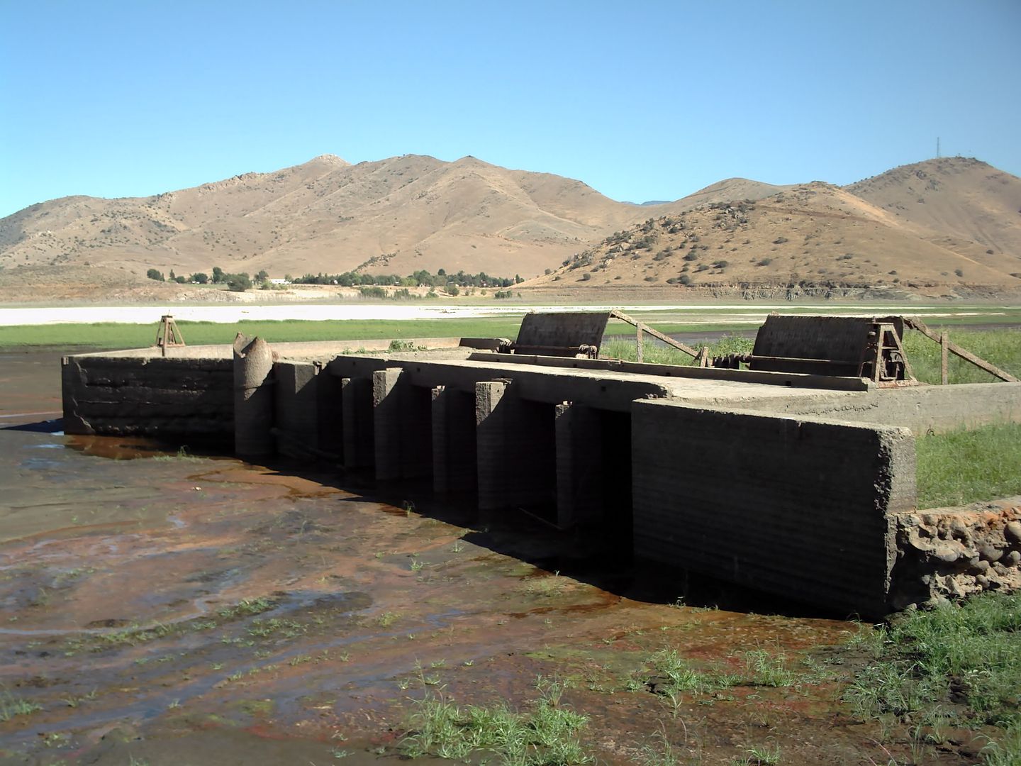
Here's a picture I took of a river lock when the lake was at about 30% capacity at the north portion of old Kernville.
http://i100.photobucket.com/albums/m20/jtorres176/lock.jpg
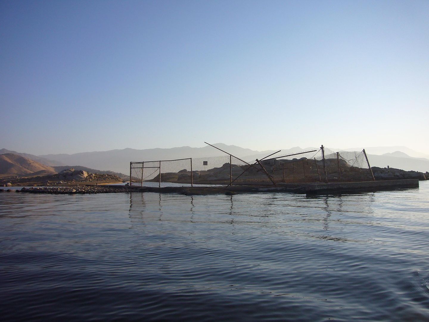
And another picture me kayaking near the end of the canal near where the Main dam is today, the chain link fence is recent to warn of the structures when the lake gets low to keep boaters and swimmers away from the unusual current caused by the old canal beneath the surface.
http://i100.photobucket.com/albums/m20/jtorres176/kayak2.jpg
I was just amazed that I've driven by these things 100 times and didn't know they existed until this year. I'm planning on buying a waterproof camera case today to take some better pictures from the water of some of these old structures that may not show up for another decade or two before the rain starts and covers them again.
#Comment Re: made: 2007-09-14 16:46:14.048762+02 by:
Dan Lyke
Cool! I've thought it'd be fun to go up and take a closer look at the mothball fleet near Suisun city, although the scale of those and their location makes me wonder if a novice in a kayak in that area is really a good idea.
And there are a number of industrial archeology sites that I still haven't explored out here, there's a set of kilns somewhere out near Dogtown on route 1, a mine over on the Tamarancho Boy Scouts property that might be legal to get to with a day pass, and there's all the old remnants of the railroad that used to run out here, including the tunnel through White's Hill that's apparently now a 2 million gallon water tank.
It occurs to me that I should also dig through and see if I can scan some old pictures of my high school years which include exploring two old abandoned steam locomotives out in the middle of nowhere in Maine, along the Allagash wilderness waterway.
#Comment Re: made: 2007-09-14 17:09:37.02219+02 by:
JT
Oh the mothball fleet looks awesome. I had actually thought of going to
Point Reyes off of the Santa Barbara coast to go kayak caving. There's supposed to be 255~ documented caves depending on the tide level. We've been just throwing the kayaks into the back of my car and exploring local places here lately, but I've just ordered a nice Yakima rack so we can do some longer distance trips.
If you haven't been there and you get a chance, I'd also suggest
Mono Lake, a lake 6400 feet ASL which has a seemingly liberal
boating policy for kayaks for looking at birds and
volcanic tufa on Paoha Island in the middle of the lake.
#Comment Re: made: 2007-09-14 17:20:54.762074+02 by:
ebwolf
So, what are the odds that Steve Fossett and Jim Gray are actually in some Galt's Gulch?
#Comment Re: made: 2007-09-14 17:23:24.73598+02 by:
ebwolf
Point Reyes isn't near Santa Barbara but it is spitting distance from Dan's house in Marin County!
#Comment Re: made: 2007-09-14 17:48:28.245836+02 by:
Dan Lyke
JT, I don't know of any kayakable caves up in this way, but there are a few hikeable caves if you plan the hike with the tides. If you're up as far as Point Reyes (which is north of SF, quite a distance from Santa Barbara), give me a holler, we should get together.
 I've hiked around the tufa towers at Mono Lake, but paddling out there would be fun. However, from here if I were going to drive over to Mono Lake I'd undoubtedly get sidetracked up at Tenaya Lake or Tuolomne Meadows. I do love the eastern side of the Serria, though.
#Comment Re: made: 2007-09-14 17:50:13.86633+02 by:
JT
I was backwards there.
Channel Islands National Park is actually the caving kayak trip, Point Reyes was the seal trip I was looking into at Tomales Bay, which is a big harbor seal area with great camping. It's supposed to be nice calm waters and plenty of wildlife.
Sorry to get things so off topic from archeology here.
#Comment Re: made: 2007-09-14 17:54:22.88382+02 by:
JT
This year we only made it as far as Morro Bay and Cambria, next summer we want to do the Big Sur to San Francisco trips. It's my first year living here, so I'm getting the grand tour of the state from a native resident section by section. Of course we'll have the kayaks on whatever trips we do, so if we get in the area, I'll have to give you a call. I feel like I know you already from all meuon's stories about you.
#Comment Re: made: 2007-09-14 18:01:18.8796+02 by:
Dan Lyke
Tomales Bay is a stone's throw from where I live, it's where Eric and Scott and I repeatedly dunked a kite while trying to convince ourselves that hanging a camera off it in the gusty winds to get some overhead shots of various old fishing boats and rotting piers was worth a shot.
So, yeah, large expanses of protected saltwater, probably gazillion seals and assorted other wildlife, and near-term archeology. Old piers, half-sunk fishing boats, and the various remains of the old narrow gauge railroad, although that was two world wars ago so anything iron is long gone to scrap, but the grade cuts and some of the buildings still exist.
#Comment Re: made: 2007-09-14 18:30:29.351941+02 by:
JT
I remember watching Eric taking balloon shots from meuon's wedding, the pictures that I saw were amazing. I'd bet an overview of any historical area would be wonderful. One of the reasons that I wanted to take pictures of old Kernville is because there aren't many pictures of the original town in the local museum. It'd be interesting to have some perspective of how it exists now for some type of comparison when they're exposed in another time when the lake is drained to such a low level.
Aerial shots would be amazing of some of these structures, but with the unpredictable gusty wind in the valley here, chances of getting any decent shots is miniscule at best.
#Comment Re: made: 2007-09-14 18:39:50.031975+02 by:
Dan Lyke
My experience of KAP (or watching Eric do balloon aerial photography) is that it's all a crapshoot, and that if you get the camera back in one piece it was a good flight. If you get a picture of something other than the kite string and your head, it was a great flight.
When I've got a few nickels to rub together again, I think it'd be cool to set up a basic kite with an autotimer, just to play with.
#Comment Re: made: 2007-09-14 19:30:42.163244+02 by:
ebwolf
KAP is a little more predictable than what you saw - but it's still not the kind of thing you want to bet on for a paid shoot. Scott and I both knew that wind was a little wanky that day. The balloon is a little more predictable, especially in areas where you can predict zero-wind conditions. But that's all part of the fun!
The day Dan is talking about, we tried to shoot some derelict vessels near Point Reyes. The windy was choppy and I was flying my FlowForm8 - which I have yet to get any decent results from. Scott had his Rokakku, but didn't want to risk it over the water. We flew the Rok over a nearby church later with the opposite in wind - almost none!
#Comment Re: made: 2007-09-23 20:10:01.518008+02 by:
Dan Lyke
Update here on the phone call I just got from one of the authors of River Children, a book about growing up near and in Kernville and the area that's now inundated by Lake Isabella.
#Comment Re: made: 2007-09-27 21:31:15.067626+02 by:
JT
[edit history]
while adventuring, I came across a break in the old river canal which used to guide the river through old Kernville. I took a few pictures from exploring in the canal and thought I'd share. I found a second river lock, the one that's documented instead of the one from above which I can't find a record of in the musem.
Approaching from inside of the canal it was hard to tell what it was until I got fairly close, I thought it was just a dead end at first
My "adventure gear" I pulled up and dragged my kayak up the side of the wall knowing I'd have quite a walk carrying that thing. It was worth it for the pictures.
Filter gratings to keep trees and stuff out of the river
A screw gear closeup which is what raises and lowers each of the locks. The motor and protective grating are missing from this one
The protective grating and motor housing without an actual motor in it.
I just think this stuff is neat since it's mostly underwater and rarely seen. This particular lock will show at least part of the fence surrounding it at the end of the summer in some years, but it's rarely fully exposed like this. The last time the lake was exposed this far was 1972, as shown by the top picture in the (crappily) scanned newspaper photo. The bottom picture is when the lake was above 90% capacity in 1995.
In the 1977 photo, the lake didn't have the percentage recordings that it does now, but the lake is about 12-18 inches higher than that photograph at the moment and is near 20% capacity.
#Comment Re: made: 2007-09-27 22:14:15.68765+02 by:
Dan Lyke
Cool! So are those locks, which I think of as devices for bringing boats past dramatic changes in water level, or gates? Or do I have my terminology wrong?
And is this being as low as the '70s a severe drought, or is there some other water management issue going on?
#Comment Re: made: 2007-09-27 23:08:03.251863+02 by:
JT
That's actually one type of lock, along the lines of moving boats through the panama canal or the elevated canal in Hamburg. This type is for controlling the flow of water through a river, they could use these devices to restrict the amount of water that went through the river in an attempt to prevent the town from flooding.
In the 70's there was an issue with the dam compounded with the drought. Today's issue is quite the same, we've been under drought conditions for two years now and there was elevated seepage at the main dam, so they drained off a good bit of it while the Corps of Engineers performs testing and possibly repairs. The lake will remain relatively low until 2008/09 until the testing and/or repairs can be completed. That, coupled with the drought and minimal snowfall last year, brings the lake to one of the lowest levels it's been in decades.
#Comment Re: made: 2007-10-01 14:37:25.362607+02 by:
JT
[edit history]
NPR did a story yesterday on the Mothball Fleet. I love the noises in the background during the stories on NPR. Requires realplayer to listen.
We will not edit your comments. However, we may delete your
comments, or cause them to be hidden behind another link, if we feel
they detract from the conversation. Commercial plugs are fine,
if they are relevant to the conversation, and if you don't
try to pretend to be a consumer. Annoying endorsements will be deleted
if you're lucky, if you're not a whole bunch of people smarter and
more articulate than you will ridicule you, and we will leave
such ridicule in place.