up the Napa valley
2004-06-07 17:50:31.8434+02 by Dan Lyke 3 comments
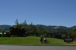
 Had a very cool weekend. On Friday evening, we drove
up to the town of Napa, where we camped at Skyline Park, a private park with a
very nice garden of native California plants (which we need to go back
and explore next spring), and a lot of horse, hiking and biking trails
(which we didn't explore).
Had a very cool weekend. On Friday evening, we drove
up to the town of Napa, where we camped at Skyline Park, a private park with a
very nice garden of native California plants (which we need to go back
and explore next spring), and a lot of horse, hiking and biking trails
(which we didn't explore).
Saturday morning we drove up to Middletown and to a tour of one of the CalPine geothermal generating plants. We were kinda hoping to see steaming fumaroles, but they don't take people back to where the superheated steam leaks out of the ground because the ground is unstable, so we had to settle for seeing the well heads and plant from where they extract the steam and generate power with it. This is a picture from the sulfur extraction part of the plant, since the steam is coming up from a mile and a half or two underground it contains a lot of gnarly stuff, so as a part of cooling down the water and putting it back into the ground (and yes, they are seeing the possible effects of extracting too much water from near the magma, so they recycle as much water as they can, and contract with local water districts to take wastewater and pump it back down) they filter out lots of sulfur, some mercury, and assorted other nasties. Need to hook up with a geology class sometime and get the tour of the less stable terrain.
 We decided to camp at the Napa County Fairgrounds in
Calistoga, so we headed back down from Lake County to Calistoga, on
the northern end of the Napa valley. Calistoga was so named by Sam
Brannan 'cause he was trying to create a Saratoga like spa region in
California. He died broke, but the name stuck, and there are also
references to "Sarafornia" around town. On the way back into town we
stopped at California's Old Faithful Geyser, watched an eruption, then went
and got the camp set up so we could get on the bike.
We decided to camp at the Napa County Fairgrounds in
Calistoga, so we headed back down from Lake County to Calistoga, on
the northern end of the Napa valley. Calistoga was so named by Sam
Brannan 'cause he was trying to create a Saratoga like spa region in
California. He died broke, but the name stuck, and there are also
references to "Sarafornia" around town. On the way back into town we
stopped at California's Old Faithful Geyser, watched an eruption, then went
and got the camp set up so we could get on the bike.
 Back on the bike we pedaled south along the ample
shoulder of Highway 128/29 to Bale Grist Mill, a restored
mill first built back in the 1840s or thereabouts, and watched the
ancient machinery at work.
Back on the bike we pedaled south along the ample
shoulder of Highway 128/29 to Bale Grist Mill, a restored
mill first built back in the 1840s or thereabouts, and watched the
ancient machinery at work.
 Tooled back into Sonoma for an iced drink, then
kicked it out down Silverado Trail for a few miles, across through the
vineyards of Napa valley, then back up the other side. Probably got in
a good 25-30 miles of biking, through the vineyards, along roads with
nice wide shoulders. Got back to camp in time to make a nice dinner,
watch the folks next to us play horseshoes while we critiqued their
style, and get a good night's sleep.
Tooled back into Sonoma for an iced drink, then
kicked it out down Silverado Trail for a few miles, across through the
vineyards of Napa valley, then back up the other side. Probably got in
a good 25-30 miles of biking, through the vineyards, along roads with
nice wide shoulders. Got back to camp in time to make a nice dinner,
watch the folks next to us play horseshoes while we critiqued their
style, and get a good night's sleep.
 The next morning we pedaled back down to the Bale Grist Mill again
because we'd been short on cash the day before and both needed to pay
for our entrance fees and buy some of the flour we saw ground. Ended
up with a bag of polenta and two of a pastry flour ground from einkorn
wheat. There'll be scones in our future.
The next morning we pedaled back down to the Bale Grist Mill again
because we'd been short on cash the day before and both needed to pay
for our entrance fees and buy some of the flour we saw ground. Ended
up with a bag of polenta and two of a pastry flour ground from einkorn
wheat. There'll be scones in our future.
 On the way back stopped to pose in front of the very
cool delivery truck sculpture in front of the Calistoga Mineral Water
Company. Back in Calistoga we wandered over to the Sharpsteen
Museum, founded by Disney animator Ben Sharpsteen it's a neat look back
at the history of Calistoga, and while a lot of small-town museums end
up being a collection of junk, this one kept us reading the plaques
all the way through, long enough that while we were originally going
to pedal up to the The Petrified Forest we decided to load the bike back on
the car and drive up.
On the way back stopped to pose in front of the very
cool delivery truck sculpture in front of the Calistoga Mineral Water
Company. Back in Calistoga we wandered over to the Sharpsteen
Museum, founded by Disney animator Ben Sharpsteen it's a neat look back
at the history of Calistoga, and while a lot of small-town museums end
up being a collection of junk, this one kept us reading the plaques
all the way through, long enough that while we were originally going
to pedal up to the The Petrified Forest we decided to load the bike back on
the car and drive up.
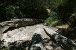 The Petrified Forest is a bunch of relatively young
petrified logs, redwoods and one pine. Because of their low relative
age and that there wasn't much interesting geologically going on over
them after the initial eruption which covered them in ash they aren't
very colorful, but what they lack in color they make up for in
texture. Unlike our
experiences in Utah, you could count the rings and clearly see
texture in the bark on these logs, but there was nothing there that'd
take to polishing very well.
The Petrified Forest is a bunch of relatively young
petrified logs, redwoods and one pine. Because of their low relative
age and that there wasn't much interesting geologically going on over
them after the initial eruption which covered them in ash they aren't
very colorful, but what they lack in color they make up for in
texture. Unlike our
experiences in Utah, you could count the rings and clearly see
texture in the bark on these logs, but there was nothing there that'd
take to polishing very well.
Most of the logs in this preserve are fenced off to prevent picking, and most of them have had to be artificially excavated, at least one down a long tunnel (which you can look down, but not go into). On Sundays at 2:00 there's a walk up into the fields above the trees, lead by one of the family involved in the upkeep of the forest who's very enthusiastic, which ends up at an ash mud flow in which you can see basalt, pumice, and petrified wood chips.
Inspired by this, on our way home we stopped along the Russian River to look for assorted rocks and realized we need some good references on geology and earth science to refresh all that stuff that went in one ear and out the other around ninth grade, so we're going to have to seek out that and start mapping out finds in various places. Yet another large map on the wall at home, I must get some of this stuff onto computer.
And home at a reasonable hour to head on over to the Cafe Amsterdam for a light dinner, listen to Jazz Philosophy do a set, then crash and marvel that as good as you think a sleeping mat and bag are, a good matress and sheets are so much nicer...