Today I learned about W State Rd
2024-03-27 17:15:02.544796+01 by
Dan Lyke
1 comments
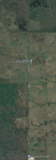 Today I learned about W State Rd 84, near Fort Lauderdale Florida. As one wag commented, "it looks like a road sine".
I wonder what the lane width vs general travel speeds on it are, and collision rates, especially vs the sorts of straight rural roads that often connect these sorts of places...
https://www.google.com/maps/pl...1373174!16zL20vMHJqMHo?entry=ttu
And Seminole Tribune on groundbreaking on efforts to straighten it.
[ related topics:
Photography Mathematics Maps and Mapping
]
comments in descending chronological order (reverse):
#Comment Re: Today I learned about W State Rd made: 2024-03-27 20:09:36.884214+01 by:
spc476
Living near Ft. Lauderdale and being familiar with State Rd 84, I was thinking that doesn't look like the 84 I know ... it's the wrong orientation and not nearly enough urban sprawl—was that a picture from years ago? But no, it's way out in the middle of the Everglades.
I had to follow along on the street view on Google quite a ways to find a speed limit—30 mph through the Miccosukee Reservation until you hit the Seminole Reservation, where it goes up to 45 mph. Leaving (through to north) the Seminole Reservation, it goes up to 55 mph, but that's far past the sine wavy part.
I don't know collision rates, but in the past (talking up until the 1990) what is now I-75 used to be Alligator Alley, a dead-straight, two lane road cutting east-west across the state, and it was notorious for its death toll due to collisions. It's less now that it's at least two lanes each way.
We will not edit your comments. However, we may delete your
comments, or cause them to be hidden behind another link, if we feel
they detract from the conversation. Commercial plugs are fine,
if they are relevant to the conversation, and if you don't
try to pretend to be a consumer. Annoying endorsements will be deleted
if you're lucky, if you're not a whole bunch of people smarter and
more articulate than you will ridicule you, and we will leave
such ridicule in place.
 Today I learned about W State Rd 84, near Fort Lauderdale Florida. As one wag commented, "it looks like a road sine".